
Bluenest by Globalvia, EUREKA and EGNOS combined: The Palma de Mallorca EUREKA Demo Day
In February 2026, Bluenest by Globalvia successfully performed a long-range UAS demonstrator flight to showcase Vertiport Collaborative Traffic Management (VCTM) within the European EUREKA project Solution 2 bringing together key stakeholders from across the Innovative Air Mobility (IAM) ecosystem. The demonstration consisted of over 33 km Beyond Visual Line of Sight (BVLOS) flight from Palma de Mallorca Airport (LEPA), which is the third in traffic flow in Spain, to Son Albertí (LEJF), a nearby aerodrome, using a RigiTech Eiger ER03 drone platform taking 21 minutes to cover the full flight.
The event proved EUREKA Solution 2’s purpose of optimizing transport logistics with IAM and VCTM under real operational conditions. This time, such innovative collaboration sped up the transportation of medical samples, a kidney in this case, from Son Espases main hospital in the capital city to a remote region in Mallorca Island.
The EUREKA Solution 2 mission, conducted in a U-space driven scenario, was conditioned by a highly challenging operational environment in adverse meteorological conditions. This BVLOS flight was conducted at nominal altitudes of 60–80 m Above Ground Level (AGL), successfully achieving a high level of coordination between U-space Traffic Management (UTM) and traditional/manned Air Traffic Management (ATM) actors: ENAIRE, as Air Navigation Services Provider (ANSP) and Common Information Service Provider (CISP), AENA as Palma Airport operator, Son Albertí aerodrome, Unifly as U-space Services Provider (USSP), Bluenest by Globalvia as the drone operator & GCS-USSP integration and the Illes Balears’ Health Care Service as provider of the medical samples.
The operation was authorised by the Spanish Aviation Safety Agency (AESA), under SORA Methodology, resulting in a SAIL II risk level operation, following the submission of a full Concept of Operations and safety case.
This VCTM framework aims to showcase safer, efficient, reliable and coordinated operations even in BVLOS and adverse meteo. To ensure the required predictability, and accurate positioning, the aircraft navigation relies on redundant Global Navigation Satellite System (GNSS) positioning integrated into the onboard flight control system, providing continuous PNT information for automatic flight execution, trajectory tracking and contingency management, with EGNOS augmentation, Europe’s Satellite-Based Augmentation System (SBAS), supporting navigation performance throughout the mission, which is notably relevant for operations under SAIL II.
The mission in Palma de Mallorca therefore represents a concrete step in the evolution of EGNSS (European GNSS) services for UAS and IAM operations. By integrating GNSS and SBAS-based navigation in IAM operations within a SAIL II regulatory framework U-space and airport airspaces, the flight validates the operational foundations required for future missions and the deployment of useful high-impact use cases, such as the optimization time and costs of time-dependent activities in hardly accessible areas, such as medical logistics services, as well as keeping the highest safety standards
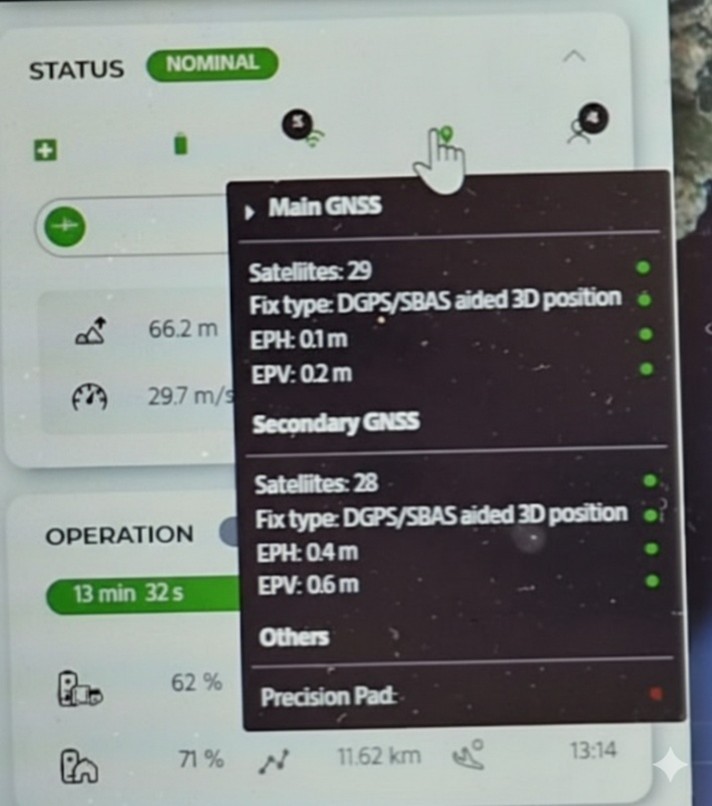
Figure 1. Snapshot of Ground Control System during the operation, showing the status of GNSS navigation systems with SBAS activated. Source: Bluenest
While technology and regulation continue evolving, all indicators suggest that EGNOS will be essential in providing the integrity, accuracy, predictability and trust required by IAM vehicles, just as it has reliably done in conventional aviation. The EUREKA Solution 2 Demo Day therefore stands as a milestone not only for IAM, but also for the future adoption of EGNSS services as a safety enabler for the next generation of air transport.
EGNOS and Innovative Air Mobility (IAM)
IAM involves the safe, secure and sustainable transport of passengers and cargo enabled by new-generation aerial vehicles integrated into multimodal transportation systems. Due to the novelty and complexity of these operations, GNSS has become a fundamental element of not only low-risk UAS navigation, with GNSS receivers integrated as standard equipment on most commercial platforms, but also in other complex scenarios, such as IAM environments. European GNSS, through Galileo and EGNOS, provides significant added value to those.

Figure 2. EGNOS geostationary satellites. Source: ESA
EGNOS improves the accuracy, integrity and reliability of GNSS positioning and has been supporting safety-critical aviation navigation for more than a decade through its Safety-of-Life (SoL) service. As IAM operations evolve towards higher levels of automation and airspace integration, EGNOS is expected to play a similar enabling role for UAS and Vertical-Capable Aircraft (VCA), as in current helicopter manned operations.
As highlighted in the EGNOS Performance in UAS Operations white paper, the growth of IAM will lead to more operational demanding scenarios, where risks to people and infrastructure are higher. While positioning requirements for these more stringent operations are however still to be standardised, in such scenarios, the accuracy and integrity of the position become critical for collision avoidance, precise navigation and overall operational safety. These scenarios seem to be promising and challenging for the implementation of an EGNOS-based service tailored to UAS operations. Its availability, analogous to today’s EGNOS Safety-of-Life service for manned aviation, would therefore represent a major step forward for the sector.
About Bluenest by Globalvia and the EUREKA project
Bluenest by Globalvia is a leading European infrastructure developer specialised in vertiports and IAM ecosystems. As part of Globalvia, one of the world’s largest transport infrastructure groups, Bluenest combines airport-scale operational expertise with digital airspace software integration, U-space deployment and urban infrastructure development. Bluenest is actively supporting the deployment of drone logistics, eVTOL operations and medical transport services across Europe, working closely with regulators, airports and technology providers to enable safe, scalable and sustainable air mobility, as shown with its participation in EUREKA project.
EUREKA (European Key solutions for vertiports and UAM) is a SESAR project led by EUROCONTROL and funded by the European Union aimed at delivering deployable solutions for vertiport operations and IAM integration through four solutions. The flight conducted in Palma de Mallorca took place within the context of EUREKA Solution 2, in which Bluenest brings a strong “operations + infrastructure” perspective to validate concepts in real conditions, linking vertiport readiness, U-space services and regulated flight execution, guaranteeing the safest eVTOL operations.