Exciting news about the EGNOS App! The new functionality “EGNOS visibility city map” is now a fact.
With this new feature, you can now check the EGNOS GEO satellites visibility in urban areas inside the EGNOS service area. This functionality was previously available at the EGNOS visibility city map section of the EGNOS User Support Website, and is now available at your fingertips as well!

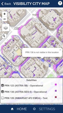
The EGNOS visibility city map provides support to users in terms of EGNOS usability within cities, allowing them to check if they are in direct visibility with the EGNOS GEO satellites (no obstacles like buildings) in order to obtain the committed performance.
EGNOS users can select the different operational and/or test EGNOS GEO satellites and click in the map to check its visibility in the selected city. In order to find the desired location, just use the magnifying glass or browse the map with your fingers. By tapping at any location, information on satellites visibility is directly displayed.
Update now your app to version 2.3.1. Being informed has never been so easy!
| iOS | Android |
| App Store | Play Store |
What do you think about this improvement? Feel free to post your feedback on the markets or share it by contacting the EGNOS Helpdesk.

